
DREAMS AND SCHEMES
PROJECTS AND PROGRAMS TO
IMPROVE THE CHICAGO REGION
Craig H Hullinger
1987
INTRODUCTION
The Chicago region contains many attractive and desirable communities. However, the region has suffered greatly from the recent recession. The Southern Suburbs and the industrial portions of the City of Chicago have been the most negatively impacted during this financial downturn. The purpose of this discourse is to outline some major improvements to the area which will improve the Chicago region, both for current residents and for prospective investors. Some of the projects listed here are underway, while others have not been publicly discussed.
This paper is but a small step in the process required to bring such improvements into fruition. The Southern Suburbs are highlighted in this publication. This is due to two basic reasons. First, the Southern Suburbs have received the least development in the past few years and are, therefore more readily accepting of innovative proposals and second, the area has more developable areas as opposed to other areas of the region. Likewise, the southern portion of the region is best known to the author.
This paper is but a small step in the process required to bring such improvements into fruition. The Southern Suburbs are highlighted in this publication. This is due to two basic reasons. First, the Southern Suburbs have received the least development in the past few years and are, therefore more readily accepting of innovative proposals and second, the area has more developable areas as opposed to other areas of the region. Likewise, the southern portion of the region is best known to the author.
I apologize to anyone whose ideas appear here without credit. I have had untold numbers of discussions with numerous individuals on different proposals. Many of the ideas that I have written about have no doubt originated elsewhere.
Some of the proposals are whimsical, some serious, and some controversial. Some of them will be constructed, while others will be added to the ever growing body of rubbish ideas. They may also prompt other better ideas for development.

* I wrote this book thirty years ago. I am now putting it on this blog. I will keep the text as originally written, but add photos - the original had black and white sketches. And I will write short notes about the status of the proposals in bold italics - some of them have been developed while the rest await.
Recreation and Open Space
RECREATION AND OPEN SPACE
Chicago is located in America's heartland. It has the physical characteristics of the flat midwest. While very productive, our landscape could do with a few man made improvements. The addition of a mountain, an island, and a river would improve the region substantially.
 MOUNT SOUTH CHICAGO
A major gateway to Chicago and the southern suburbs is located where 130th Street intersects Interstate 94. The area is a major industrial complex. It includes the Calumet Harbor Port Industrial properties and an extensive land fill area just south of 130th Street. The South Shore Commuter Railroad parallels 130th st. In years past a train station served the harbor, where sailors from ships in the harbor could flag trains.

The summit of the mountain would be an appropriate location for a major piece of sculpture. It would provide an impressive entrance into the region. It would be a unifying symbol for the broad shoulder area of the Chicago region. It logically should be a major steel sculpture, in honor of the steel making industry of the region.
The train station at the junction of 130th and the Calumet Expressway should be reopened with a first class parking lot added. This could provide a dual function--access for visitors to the Mount South Chicago recreational area and parking for commuters using the South Shore Commuter Railroad. Visitors could also ride the South Shore to visit the park.
The Port Authority also needs to upgrade the appearance of their facility from the expressway. The development of quality buildings along the Interstate coupled with a landscaping treatment should serve to improve the appearance and marketability of the Port Authority property.

The landfill companies may be willing to donate the land, since old landfills are difficult and expensive to redevelop into commercially useful property. In addition, the tax savings for donations could be substantial. Also, the public relations value of the dedication would be significant. The complex could thus be developed relatively inexpensively.
This concept is not new, and in fact, a number of recreational facilities have been developed from landfill sites. Several facilities are planned or completed in the western suburbs. But none of the other projects would be of the size possible for Mount South Chicago, nor would they have the amazing view afforded by Mt. SC. This view includes Lake Michigan, Calumet Harbor, the vast industrial region, and the loop.
Mount South Chicago is a workable concept that should be implemented. Developing the site is difficult because of the multitude of governments and institutions involved. But the transition is possible, and it should be completed quickly to alleviate the impact on the long suffering neighbors of the landfill. And there can be no question that Chicago needs a mountain.

Chicago, and particularly the southern suburbs, need an improved river and recreational area. The existing Cal Sag Channel could be upgraded to be a major attraction for the area.
The Calumet Sag Channel connects Lake Michigan, Calumet Harbor, and the Chicago Sanitary and Ship Canal. The property along the channel includes major industrial areas, residential districts, and forest preserves. The channel and the property adjacent to the canal is owned by the Metropolitan Sanitary District. It is currently underused despite recent efforts by the Metropolitan Sanitary District to market the property. The channel and adjacent property are typically ignored.
The channel is not very observable. Most people driving along or across the channel are not aware of its presence. The land uses along the channel vary tremendously. They include virtually every type of development.
The channel begins at Lake Michigan at 90th St.and proceeds south through a heavily industrialized area. At 125th St. the channel interconnects with Calumet Harbor. At 150th St. the channel interconnects with the Grand Calumet River. It then proceeds westward through the communities of Burnham, Calumet City, Blue Island, Crestwood, and Alsip. Next, the channel passes through the communities of Palos Hills, Palos Heights, and Palos Park, and the major western forest preserves of Cook County. The channel ends at the Chicago Sanitary and Ship Canal in Lemont. It is proposed that Chicago, the Southern Suburbs, the Cook County Forest Preserve District, the Metropolitan Sanitary District, and the Calumet Harbor Port Authority begin to improve the use, appearance, and image of the channel.
The lands along the channel should be leased to the Forest Preserve District and/or local park districts to be developed into recreational areas. Where appropriate, they should be leased or sold to developers for office and industrial development. A continuous trail should be developed on both sides of the channel. Several small harbors could be developed along the channel.
 The channel should be incorporated into and enhanced by the National Heritage Corridor, which is a proposal to develop the Chicago Sanitary and Ship Canal, the Illinois and Michigan Canal, and the Des Plaines River into an economic development and recreational area. The National Heritage Corridor will bring a major new national park into the Chicago region. A unique concept is being developed--that major industrial areas can coexist with open space and historical preservation uses and that a major national park can be developed in an urbanized region. Since the land and waterway are already owned by government, the expense to acquire and develop the corridor is relatively low.
Implementation of the beginning of development of the channel is difficult. It requires the leadership of government, planning commissions, the news media, environmental groups, industrial development groups, and concerned citizens--all with competing interests and concerns. It is proposed that the plan commissions of the communities along the Calumet Sag Channel conduct meetings to discuss the pros and cons of the development of the channel. An informal planning process should begin to bring the concept to fruition.
The upgrading of the Calumet Sag Channel from a neglected area into a fine resource for the community is a definite possibility. The governments and civic organizations of the southern suburbs and Chicago should begin work in earnest to bring a quality river corridor into reality.
It is happening now!!!

Very nice to see this happening now. Congratulations to all who helped make this a reality. calsagtrail.org
ISLE CHICAGO (This one happened)
Our region needs an island. We have a beautiful lake and lake-front park system, but the lake is empty to the naked eye. An island would add a touch of mystery and intrigue to an otherwise conservative mid western Great Lake.
Islands have a permanent and honored place in literature. People have been marooned on them, imprisoned on them, and vacationed on them. A great deal of money is spent on trips to islands in the Caribbean, the British Isles, and the Greek Islands. Stories and ballads have been written about islands. It is clear that Chicago will never be a truly world class city without an island to call its own.
Now it is true that Chicago has a Blue Island and a Stoney Island and that a number of Chicagoans vacation at these attractive garden spots. But these Islands are not in Lake Michigan. We need an island in the lake.
A number of people feel that Lake Michigan should be forever free and clear and that the wide open vistas should be totally preserved without obstacles. But surely, one little island would not ruin the view! A well landscaped island will enhance the view of the lake.
The location and size of the island can be determined after research and detailed planning. The uses on the island could vary, but a mixture of recreational and commercial uses would be appropriate.
The Forest Preserve District would be the logical developer of an island in Lake Michigan. Most forest preserve land is in distant suburbs, far from the densely built city. A forest preserve island would provide needed recreational space.
A combined effort with commercial developers could result in an interesting island with limited costs to the taxpayer. The island should have limited restaurant facilities. Strict environmental controls would, of course, be necessary to prevent ecological problems. The development of the island would increase the amount of beach and shallow water area, which should promote wildlife.
The name of the Island will be difficult to select. The following are a list of some of the possibilities:
----- Treasure Island------ ---- Captain Streeter Island
----- Isle Washington ----- ----- DuSable Isle
----- Blue Island ----- ----- Byrne Island
----- Stoney Island ----- v-----Eisenhower Isle
----- Daley Island ----- ----- Michigan Isle
----- The Greek Isle ----- ----- Cub Island
----- Ireland ----- ----- Bear Island
----- Atlantis ----- ----- Sox Island
----- The Chicago Isle ----- ----- Stockyard Island
----- Gold Coast Isle ----- ----- Streeterville Island
----- Sawyer Island ----- ----- The Chicago Isles
----- Isle Rue (Named after my wife Beth Ruyle)
Chicago deserves an island. Let us give her one (and my wife also) in the near future.

(It did happen, but not the way I thought it would. Mayor Daley closed Meigs field in the middle of the night by cutting the runway up. A bit cavalier, but it is a very nice park. No reason we should not have a few more islands.)

THE CHICAGO WORLD'S FAIR - STICK IT IN THE LOOP
The proposed Chicago World's Fair was an exciting and worthwhile civic endeavor that would have enhanced the image of the Chicago region around the world. The apparent demise of the fair is unfortunate, but the fair is not over till the fat lady sings. A fair of more limited scope can still be developed.
Most of the criticism of the fair hinged upon environmental and cost considerations. The lake side site was too costly to develop and generated little urban redevelopment.
Both of these problems can be rather nicely solved by simply setting the fair IN THE LOOP! We already have a world's fair in Chicago in terms of our cultural and commercial amenities. We simply need to designate and market downtown Chicago as a world's fair and work to get international exhibitors to locate their exhibits in existing and new downtown facilities.
A typical visit to the Chicago world's fair would include a three to seven day visit to the following amenities:
Art Institute
Museum of Natural History
Planetarium
Aquarium
Museum of Science and Industry
Lincoln Park Zoo
Brookfield Zoo
world's tallest buildings
architecturally significant buildings
State Street
North Michigan Avenue
world's most interesting roller coaster (CTA Rapid Transit)
Lake Front
Pavilions from as many countries as possible
As you can see, a visitor could not even see our existing world's fair in a week's time. Even if few countries provided a pavilion, the city has existing world class world fair activities. State Street is the obvious north/south access of the fair. Many south State Street buildings are underused and could be efficiently adapted to house some fair exhibits. State Street has convenient access from all the rapid transit lines and most of the bus lines. One of the less developed east/west streets along the south edge of the loop could be another access mode/part of the fair and provide fair access from the commuter rail terminals.
The corporate leaders of Chicago can facilitate the fair by providing part of their first floors of their downtown buildings for fair exhibits. Some of our local business can move their first floor operations to other parts of their buildings or to other locations. The fair will now be inside, so we can run the fair all year long.
Other pavilion sites could be developed on empty sites near the loop or in lakefront park areas. In addition, it is also feasible to locate some of the fair attractions in other parts of the region or state. It would be interesting to solicit fair site applications from all parts of the state. Foreign exhibitors could then match locations. Frankfort would have the German pavilion; Geneva the Swiss exhibit, etc. A world's fair pavilion would be an obvious showcase on which to revitalize a small city's downtown area.
To achieve the use of existing buildings in the loop as part of the fair, a "High Tech" ticket solution is necessary. The fair should probably use computerized fare collection means similar to the method used to collect fares on the ICG commuter railroad. Fair visitors would purchase their ticket to the fair anywhere in the loop and use it to access turn styles at buildings in the loop and at the entrances to the main fairgrounds.
An alternative to the ticket approach to the fair is simply to make it free. Most of our existing facilities are free or charge a nominal fee at the door. The fair pavilions could simply adopt a similar system. The return to the city would be from tourist dollars spent and in the enhanced image and reputation to the city for future years' tourism.
This approach should also reduce the need for new transit and parking improvements. The loop presently accommodates over 1,000,000 trips a day. The peak demands for present loop traffic are primarily at rush hour. The peak travel times for fair users will occur after the morning rush hour. With an education and marketing campaign, many who attend the fair can be persuaded to travel home before or after the evening rush hour. Thus, the existing rapid transit, bus, and railway services can be more effectively used by cycling peak hour equipment on increased trips during the day and evening.
This approach also has the additional benefit of eliminating the need for substantial landfill in the lake. The landfill efforts are costly and the resulting park might not be heavily used after the fair because of its distance from residential areas.
The approach outlined in this paper should achieve the following:
LOWER INITIAL COST
NO LANDFILL
INCREASED URBAN REDEVELOPMENT IMPACT
INCREASED BUSINESS IN THE LOOP
IMPROVED ACCESS FOR FAIR VISITORS AND WORKERS
ENHANCED REVITALIZATION OF STATE STREET
REDUCED NEED FOR NEW TRANSIT AND PARKING
IMPROVEMENTS
This paper also advocates several other considerations for fair planners. In particular, it seems to be the height of the "throw away society" to build the enormous and attractive World's Fair, only to dismantle it a few short months after completion. The 1893 and 1933 Fairs appear from photos to have been wonderful additions to the city. It seems a shame that more of the buildings were not preserved.
The city should begin planning for a follow on effort that will maintain a portion of the attractions of the fair. Epcot Center could be something of a model for the follow on fair. The existing Field Museum, Aquarium, and Planetarium are remnants from previous fairs. New pavilions could be incorporated into a new Chicago entertainment and educational center that could be a world class attraction. A central concept is that people should be able to walk from State Street directly to the existing and future cultural and educational facilities developed by the fair.
It is suggested here that the Disney Corporation is the world's expert in educational and entertainment complexes. The city should begin negotiations with the Disney Corporation and other similar companies to determine if a viable permanent follow on educational/entertainment theme park could be planned to develop from the World's Fair. We have, after all, a Disney Land and Disney World on the two coasts of this country-why not a DISNEY CITY in America's heartland? Since the City of Chicago has had initial conversations with the Disney Corporation, the development of a permanent world's fair as part of the city would seen a natural step.
A follow on attraction would further enhance Chicago's reputation and attractiveness for tourism and trade shows, particularly if the park spurred redevelopment of the near south area between the loop and McCormick Place. If the entire area developed into a quality educational / entertainment / commercial / residential center, then the World's Fair would be a success not just for one year, but for many years to come.
The fair could take place in 1992 or later. Some future governor or mayor will make the fair happen, and will gain great credit for creating the fair.
We already have a world's fair in our city, we just don't think of it as a world's fair. By designating our city as a world's fair site, we can still have the fair. It won't be as it was envisioned a few years ago, but it could well become a prototype for future world's fairs. When you think about it, what could be more logical than having a world's fair in our downtown, instead of in a boon docks park?
THE 1992 WORLD'S FAIR IS ON!! IT WILL BE LOW COST, FINANCED LARGELY BY OUR DOWNTOWN CORPORATIONS, LARGELY IN DOWNTOWN, MOSTLY IN EXISTING STRUCTURES. LET US MAKE IT HAPPEN.
DISNEY CITY
There is a Disney Land on the west coast and a Disney World on the east coast. Why not a Disney City near the center of the country?
Disney City should be built near downtown, ideally within walking distance of the City's center and other tourist attractions. Disney City would have to be partially inside to operate during Chicago winters. It could be developed in concert with the World's Fair, should it occur.
O'Hare Airport is the world's busiest airport. It boasts a quality roller coaster connecting the airport to the rest of Chicagoland. The Milwaukee line of the CTA would provide an interesting access to Disney City.
The development of a Disney City would of course be a tremendous boost to the economy of the region. It would enhance the image of the city. It would generate substantial number of jobs and tax base. It would further enhance the city as one of the best convention cities in the world. The city should make an aggressive effort to attract Disney City to the region.
THE REGIONAL TRAIL SYSTEM
Trails formed along old canals and abandoned right of ways have become an important part of the recreational systems in urban areas. These systems can form great lineal parks, creating green open areas with great access from urban areas. The logical expansion of this system is recommended. A number of these trails are delineated in the following paragraphs.
ILLINOIS AND MICHIGAN CANAL
The Illinois and Michigan Canal was constructed in the early 19th century as a major part of the early development of Chicago. It connected Chicago to the Illinois River, providing access to the Mississippi River. It has largely been abandoned, but many parts of the canal and towpath are still usable.
The City of Lockport has done an excellent job in restoring portions of the canal, towpath, and surrounding buildings. The trail in Channahon has also been rebuilt and is in good condition. Their efforts set an example for the rest of the communities along the canal.
The State and several communities have been improving both the waterway and towpath. This is quality system and it should be further developed and continually upgraded.
HERITAGE CORRIDOR TRAIL SYSTEM
The Heritage Corridor is the title given to a region encompassing the I & M Canal, Chicago River, the Cal Sag Channel, and the Chicago Sanitary and Ship Canal. This great system of urban waterways was in fact our heritage in terms of transportation, commerce and industry. Many of the land uses along the canal have fallen into disuse.
The Heritage Corridor Commission has been created by Congress to oversee the development of the Heritage Corridor. It has an interesting and challenging mandate-- to create a quality national park type development in the corridor while also maintaining and improving historical and cultural aspects of the canal. In addition, economic development of the canal is also advocated.
The Heritage Corridor could be a great addition to the metropolitan area if it is properly funded and supported.
PLANK ROAD TRAIL
The Plank Road Trail concept was first developed in 1981 by the communities bordering the Penn Central Railroad south of Route 30. The railroad proposed abandonment and sale of its tracks. The rails were removed in 1981. The Plank Road Trail Plan proposed that the right of way for the railroad be purchased for use as a trail and open space area.
The communities of Matteson, Frankfort, Park Forest, Mokena, and New Lenox supported the concept. A variety of uses were considered, including hiking, biking and recreational uses. In more rural areas horse trails were proposed.
The State of Illinois, the Northeastern Illinois Planning Commission, the Will and Cook County Forest Preserve commissions, and the Open Lands Commission supported the concept, and worked to gain control of the property. The State has budgeted $250,000 for right of way condemnation.
At present, the proposal is moving slowly forward because of concern that the Penn Central may not own the land. Many of the older railroads acquired rights of way through contributions from land owners, with the stipulation that the land would revert to the original owners when or if the railroad was removed. Until the ownership issue is resolved, acquisition will be difficult.
The development of the trail would positively enhance the image of the southern suburbs. The trail would connect the historical business districts of Frankfort and Matteson to Lincoln Mall and the Matteson ICG station. Visitors to the area could take pleasant walks through these communities. The Prairie Path in Du Page County is similar to the Plank Road Trail and has served to bolster the image of its surrounding area.
This one happened. It is very nice. It took 17 years from the time we first wrote the plan until you could actually ride a bike on the trail. More about the Plank Road Trail below:

The Plank Road Trail is a nice bikepath / trail that runs east-west across Will and Cook County south of Chicago.The conversion of the old railroad to a trail was proposed by the Northeastern Illinois Planning Commission and the Will County Forest Preserve District in their Acquisition Plan prepared in 1973-75. I worked on that plan.
The project was referred to as “The abandoned Penn Central Railroad Right of Way”, which is not exactly a great marketing name. "Abandoned Penn Central Railroad Right-of-Way," didn't have the magic to stir men's souls.
The rails were removed in 1981. Bob Sullivan AICP and I prepared the The Plank Road Trail in 1981, which gave the project a much more marketable name. The project was originally proposed as a Plank Road, which was a toll road. It was never built as a Plank Road but was changed to a railroad.
In searching for a name that supporters could like we found that the project had originally been named the "Oswego and Indiana Plank Road" name that had been proposed for the route in 1849. It was never built as a Plank Road (Toll Road with planks for pavement), but we dubbed it the Old Plank Road Trail and the name caught on.
Carl Glassford formed an action committee which worked hard and successfully to get support from the communities of Matteson, Frankfort, Park Forest, Mokena, New Lenox, Will and Cook Counties, and the State of Illinois. I can remember one evening in the Matteson Village Hall. The Council was opposed to the trail - sounded like a boondoggle to them. Carl and his committee made a presentation to the Board, and they completely changed their mind. They got it that a lineal park running through their historic downtown and connecting to their regional mall and many of their residential neighborhoods was a good thing.
The State of Illinois, the Northeastern Illinois Planning Commission, the Will and Cook County Forest Preserve commissions, and the Open Lands Commission supported the concept. They began to work to gain control of the property.
It took 17 years from the time we gave it the name of "Plank Road Trail" until you could walk on the paved path. Public projects take a long time to bring into fruition.
The development of the trail positively enhanced the image of the southern suburbs. The trail connected the historical business districts of Frankfort and Matteson to Lincoln Mall and the Matteson ICG station. Visitors to the area can take pleasant walks through these communities.
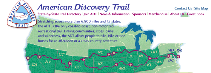
The Trail is part of the American Discovery Trail which cross the entire United States - a seriously long walk.

This one happened. It is very nice. It took 17 years from the time we first wrote the plan until you could actually ride a bike on the trail. More about the Plank Road Trail below:

The Plank Road Trail is a nice bikepath / trail that runs east-west across Will and Cook County south of Chicago.The conversion of the old railroad to a trail was proposed by the Northeastern Illinois Planning Commission and the Will County Forest Preserve District in their Acquisition Plan prepared in 1973-75. I worked on that plan.
The project was referred to as “The abandoned Penn Central Railroad Right of Way”, which is not exactly a great marketing name. "Abandoned Penn Central Railroad Right-of-Way," didn't have the magic to stir men's souls.
The rails were removed in 1981. Bob Sullivan AICP and I prepared the The Plank Road Trail in 1981, which gave the project a much more marketable name. The project was originally proposed as a Plank Road, which was a toll road. It was never built as a Plank Road but was changed to a railroad.
In searching for a name that supporters could like we found that the project had originally been named the "Oswego and Indiana Plank Road" name that had been proposed for the route in 1849. It was never built as a Plank Road (Toll Road with planks for pavement), but we dubbed it the Old Plank Road Trail and the name caught on.
Carl Glassford formed an action committee which worked hard and successfully to get support from the communities of Matteson, Frankfort, Park Forest, Mokena, New Lenox, Will and Cook Counties, and the State of Illinois. I can remember one evening in the Matteson Village Hall. The Council was opposed to the trail - sounded like a boondoggle to them. Carl and his committee made a presentation to the Board, and they completely changed their mind. They got it that a lineal park running through their historic downtown and connecting to their regional mall and many of their residential neighborhoods was a good thing.
The State of Illinois, the Northeastern Illinois Planning Commission, the Will and Cook County Forest Preserve commissions, and the Open Lands Commission supported the concept. They began to work to gain control of the property.
It took 17 years from the time we gave it the name of "Plank Road Trail" until you could walk on the paved path. Public projects take a long time to bring into fruition.
The development of the trail positively enhanced the image of the southern suburbs. The trail connected the historical business districts of Frankfort and Matteson to Lincoln Mall and the Matteson ICG station. Visitors to the area can take pleasant walks through these communities.
Much more about the Trail at oprt.org
The Trail is part of the American Discovery Trail which cross the entire United States - a seriously long walk.


LINCOLN WAY TRAIL
Old Lincoln Highway was the major east west route serving Frankfort, Rich, and New Lenox townships. Old Lincoln Highway was one of the nations early brick roads. It served as an important commercial artery connecting the east with the west. More recent reconstruction of Route 30 left portions of the Old Lincoln Highway to the side of the new road, often causing an unsightly area as the old pavement fell into disuse. The development of Interstate 80 relegated Route 30 to a secondary status. This resulted in many of the commercial structures on the roadway closing and deteriorating causing further visual blight.
By developing a pedestrian way parallel to the highway, the aesthetic appearance of the road will be improved. The safety of children traveling on the road will be increased. The area will have an additional quality feature which will enhance the quality of life and the reputation of the communities in the area.
The name of the trail is taken from a term in wide usage. Lincoln Way High School is located on the trail and is a major destination on the trail.
Important land uses that will be served by the trail include: the commercial areas of New Lenox, Frankfort, Matteson, and Park Forest and Olympia Fields; the Frankfort Library; the Frankfort Township building and swimming pool; forest preserves; Lincoln Way High School; the New Lenox Rock Island Station; Lincoln Mall; and the Park Forest ICG Station will receive direct service. Connections to downtown Mokena, Frankfort, Matteson, and the parallel Plank Road Trail should also be provided.
The trail should eventually be developed as a lineal park, with the trail providing continuity. Landscaping and park benches should be placed where possible. The trail should be identified with appropriate signage. Commercial business should work the trail into their landscaping them.
The development of the trail can take place over a number of years. Each time Route 30 is widened or improved the trail should be constructed or improved.
Each segment of the trail could be developed individually by the town, park district, township, and forest preserve district. Each segment of the trail should serve a local function when it is constructed. The following is a township by township discussion of possible development phasing.
FRANKFORT TOWNSHIP
The recent additions of the Frankfort Library and township swimming pool on Route 30 at opposite ends of the township make the early development of the trail a necessity. The trail should be on the north side of the highway, built within the right of way, but as far from the pavement as possible. The communities of Prestwick, Frankfort Square, Lincoln Estates, and Arbury Hills should be connected to the trail. A connection to Mokena along the west side of Wolf Road would also be desirable.
The portion of Old Route 30 west of Route 45 is wide and is subject to flooding. This portion could serve a dual use for flood control. The area could be excavated into a gentle swale that would accept and retain water during major floods. During periods of non-flooding the area could be developed into an attractive landscaped lineal park. Extensive berming and the use of pine trees and evergreens along the north edge of the park would minimize noise from Route 30 to adjacent residential areas.
The area west of the intersection of Route 30 and Route 45 should be extensively landscaped similar to the entry way areas of Historical Frankfort and the Savings and Loan building at Route 45.
NEW LENOX TOWNSHIP
The first connection should be through the Village of New Lenox to Lincoln Way High School, serving the commercial center of the village and the train station. Subsequently, the trail should be extended east to meet the Frankfort Township portion. Residential neighborhoods to the north and south of Route 30 should also have connections to the trail developed.
RICH TOWNSHIP
Initial development of the trail should be to connect the commercial establishments in Matteson with residential areas and the train stations. The trail should subsequently be extended east to Olympia Fields and Park Forest, with connections to residential neighborhoods. The trail should eventually be extended west to link up with western Matteson neighborhoods and the Frankfort Township portion of the trail.
SUMMARY
The development of the Lincoln Way Trail can proceed very slowly, and can be thought of as a ten to twenty year development project. Each time a subdivision or commercial development takes place on Route 30, the frontage should be developed into a landscaped pathway. Local chambers of commerce can encourage their members to redevelop existing structures into the trail. Improvements to the trail will vary according to location. The portions in commercial areas will have more urban type cross sections-- paved, with benches and intensive landscaping. The rural cross sections can be less well developed with bark chip or compacted gravel type of improvements. The trail should be attractively landscaped, signed, and promoted.
The development of the Lincoln Way Trail will be an outstanding addition to the quality communities in the area. Coupled with ongoing quality development and the development of area forest preserves, parks, and the Plank Road Trail, Lincoln Way Trail will improve the region. In time, the communities along Lincoln Way in the Land of Lincoln will become known for their quality system of landscaped walkways.
THE CITY FARM - FOREST PRESERVE
A farm should be preserved to provide our children with knowledge and understanding of farming and rural life. The farm should be an actual working farm with additional facilities for tours and education.
The farm should be located as close as possible to the bulk of the population of the area. The farm would serve as permanent open space and as a green belt separating communities.
The farm should be owned and operated by the Forest Preserve District. The district operates attractive wooded recreational areas and golf courses. A farm would be an attractive addition to the forest preserve program.
THE LAKE FRONT FOREST PRESERVE
The lakefront of Chicago is a regional resource, enjoyed by people throughout the region. It is the front door to our region. Unfortunately portions of the lakefront are undeveloped and poorly maintained. This is due in part to the cost of improvements and maintenance.
Portions of the lake front should be shifted over to the Cook County Forest Preserve District. The county is certainly in better condition to pay for substantial improvements to the lakefront, since it draws its tax base from both city and suburban areas. This would be a more equitable situation for city residents, since the lakefront is used by both city and suburban residents.
By shifting portions of the lakefront to the forest preserve, substantial improvements could be developed. This could include improved beaches, bike paths, and trails.
THE YEAR AROUND SOLAR PLAYGROUND
Chicago is the third coldest metropolitan area in the USA. During the winter, many days are simply too cold to stay outside. Chicago should follow the example of Minneapolis and Edmonton, creating enclosed walkways among downtown buildings. The city should also work with commercial enterprises and the park and forest preserve districts to develop a year around solar playground. A huge indoor park under an enormous atrium should be developed to provide summer 12 months a year.
The public sector could finance the indoor park. Major commercial recreational facilities would be located and developed within the facility. The park could become a major attraction for the region. It could be a prototype for this type of recreational facility.
The facility could contain a variety of uses. A quality swimming area with sand beaches and sunlight is obviously required. A tropical and a desert area should be provided. Private health clubs and park facilities could be attached to the facility.
RIVER MARINA
The image of the Chicago River is gradually improving due to improved water quality. A wide range of actors making concerted efforts influenced this result. These efforts must continue. The water quality of the river must continually be upgraded.
Future development should focus restaurants and activities on the riverfront. Pedestrian ways along the river should be improved, both inside and outside.
Marina development must be encouraged. The continued addition of boating facilities to the river will ensure the continued upgrading of the river appearance and vitality.
THE "OVER THE HILL" LEAGUE
It has long been an irony that advancing age slows performance and forces retirement. This occurs at the apex of an athlete's career, when he is the most popular and in the most demand. The professional is still a superb athlete, but eventually cannot compete with younger men.
An "Over the Hill" League composed of over "40" athletes should be developed. The charisma and popularity of the former stars should ensure the success of the league. The baby boom generation is the largest population cohort and is now beginning to turn 40 years of age. In this scenario the baby boom generation could continue to follow its present athletic heroes into middle age.
The following are a list of possible organizational principles:
- The majority of the athletes must be over forty, with one player fulfilling an over 50, an over 60, and an over 70 age slot.
- Members of the teams should come from a variety of sports, as follows:
2 Baseball
2 Basketball
2 Football
1 Hockey
1 Boxing
1 College level star
1 High School Star
1 Sports writer
1 No experience in organized athletics whatsoever
----------
12 Total, with alternatives as needed.
- One game per team on weekends only -- with the realization that the over the hill league is a part time job.
- The choice of the sport could vary by season (softball in the summer, basketball in the winter, etc) Chicago 16 inch slow pitch softball would be an excellent choice of games.
- Compensation would be based of a fixed percentage of the net profit, thereby avoiding the exorbitant salaries.
A team fielded in Chicago might look like this:
1 Baseball Ernie Banks
1 Baseball Ron Santo
1 Football Dick Butkus
1 Football John Morris
1 Basketball Jerry Sloan
1 Basketball Chet Walker
1 Hockey Bobby Hull
1 Boxer Mohammed Ali
1 College Mike Grabowski (No "Elite” Smithes allowed)
1 High School Craig Hullinger
1 No Experience Slats Grobnick
1 Sports Writer Tim Weigel
The question arises as to whether the league could attract the older big name players and whether enough fans would be attracted to make the effort worthwhile.
Certainly some former players could be attracted to the league. Many of these men thoroughly enjoyed the competition and fame. They could be expected to participate for a percentage of the profit. It is not beyond the realm of possibility that the league could become very profitable. Certainly, it would be no great problem to attract the high school and college stars, and individuals with no experience.
Attracting substantial numbers of fans might be difficult. It is not clear whether fans follow teams because of the prowess of young men or whether simple competition, territorial loyalty, and comraderie are more important. I personally believe the latter reasons account for team support and that the over the hill league could attract that support.
The baby boom is in its 30's and 40's now. It is already seeing most of its generation of athletes head toward retirement. The establishment of the "over the hill" league would allow this group to follow its stars through their lives and careers, instead of constantly realigning loyalties to ever younger, more overpaid, and more pampered athletes.
Several paths towards establishing the "Over the Hill" League may be pursued. The most obvious would be for each team of an existing league to form an "over the hill" team. This approach seems logical since existing teams and leagues have the know how, stadiums, contacts, and capital to implement and promote their teams. Existing leagues could also coordinate double headers and travel with their "youth" team and their "over the hill" team.
Another method for forming the league would be to form teams independent of existing teams or leagues. This approach has the strengths of attracting fresh venture capital and new and aggressive ideas, but suffers from lack of know-how and contacts.
A third implementation method would involve a player cooperative, with players providing the leadership and capital. The lack of a guiding entrepreneur would probably hinder this approach.
Subscribe to:
Posts (Atom)